Marine seismic surface wave (UMASW/MSWP)


Generalities


Near-surface marine geophysics is generally used to obtain a structural image and a qualitative assessment of shallow geology. SismOcean proposes to carry out studies using marine surface waves to obtain a quantitative assessment of geological conditions and the near surface. SismOcean is one of the few companies to offer this service and to have high skill experience in this kind of measurements.


The relatively new method of Marine Surface Wave Profiling MSWP or Underwater Multichannel Analysis Surface Wave UMASW is based on the analysis of the propagation of Stoneley-Scholte surface waves. These waves propagate horizontally at the water-sediment interface with penetration into the soil close to the wavelength (). When the rigidity properties of the sediment change with depth, these waves become dispersive, which means that their propagation speed varies according to their frequency.

UMASW principles

We generate a surface wave using an underwater seismic source. Seismic waves are recorded using a multi-channel streamer and a seismic recorder. Our online data processing software calculates the dispersion curves for every seismic shots. These curves describe the propagation properties of the surface waves and are used to calculate the velocities of the shear waves for the near surface formations (30 m deep on average). As the speed of the shear waves is directly proportional to the shear modulus, it gives us an immediate indication of the profile of the stiffness or rigidity of the sediment. This technique is non-destructive and non-invasive.


  • Correlation between MSWP and seismic CPT


Interest

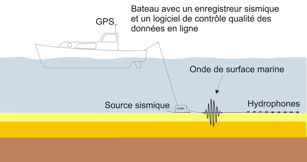
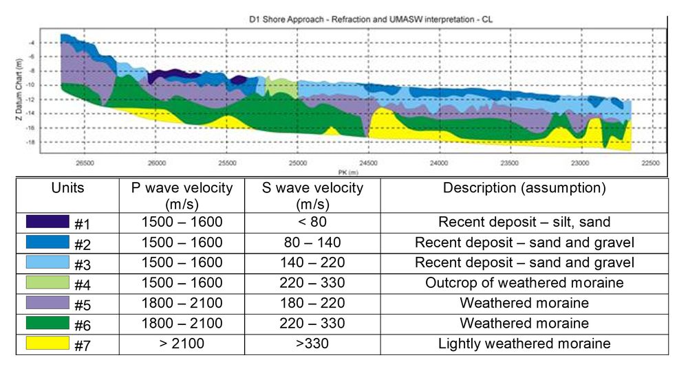
Sea surface waves can penetrate below acoustic masks linked to under saturated shallow sediments. It is also possible to measure a decreasing shear wave velocities with depth, which means that soft formations beneath hard formations can be detected. These properties are quite important for some projects.

On site the shear modulus of very soft to over-consolidated formations can be estimated along continuous profiles over several kilometers with this non-destructive, economical and recognized method.


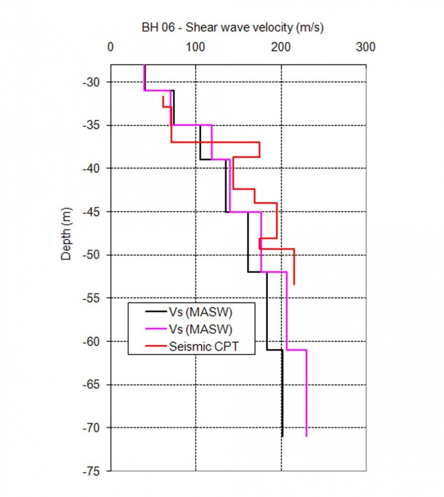
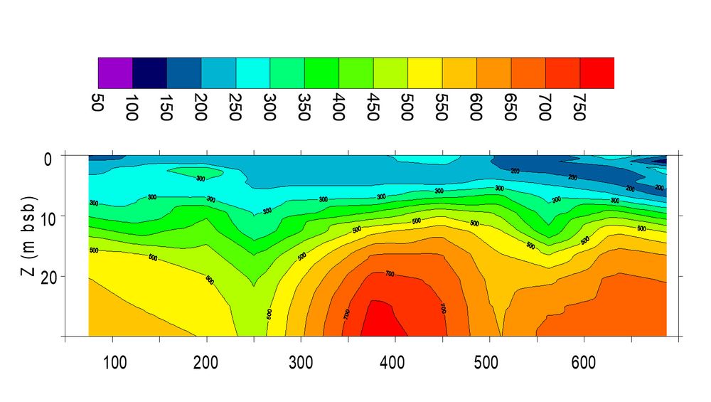
  • Shear wave velocity profile
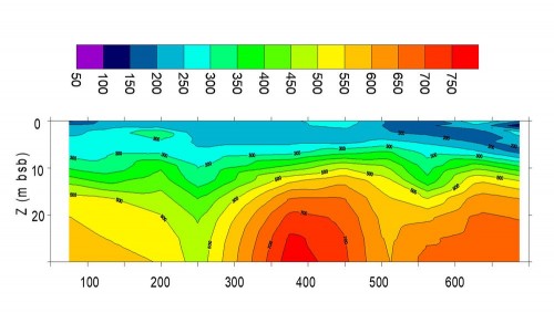

Applications

Civil engineering:
  • Port development,
  • Installation of offshore platform, anchoring area
  • Rock roof mapping,
  • Mapping of areas of low shear rates (delta, estuary, tropical areas, etc.)
  • Calculation of the shear speed and estimation of the stiffness modulus (Gmax) along profiles of several kilometers.

Dredging area studies: Evaluation of near surface conditions using the speed of shear waves,

Studies of pipeline / cable routes:
  • Landfill assessment,
  • Estimated burial costs,
  • Lift, risk of subsidence,


Equipment Description

Underwater equipment
  • From 24 channels up to 48 channels streamers
  • Receivers spacing adapted in function of the need.
  • Marine seismic source, Umbilical,...

On board equipment
  • Seismic recorder
  • On-line in-house QC software
  • On-line in-house surface wave data processing software


  • On-line in-house surface wave
    data processing software (signal and dispersion)


System features

  • Water depth range 0-50m.
  • Penetration range up to 30 m average, 50 m observed
  • Up to one shear wave velocity profile every 20 m along route
  • Estimated accuracy at 10% of actual values
  • Shallow water operations do not limit penetration range
  • Vane tests can be directly correlated to MSWP results
  • Penetrates acoustic masks
  • Detects shear wave (stiffness) inversions
  • Measures Gmax of very soft soils up to consolidated soils or bedrock
  • Land version available


Results

In function of the soil condition, the same equipment and the same data acquired can be used for the UMASW and refraction wave interpretation. (see example here below and Marine Seismic Refraction section)


  • Analysis combination of both seismic refraction and surface wave results