HDD, pipeline route (marine refraction, UMASW)


Objectives


Combination of both results from refraction seismic and surface waves to better identify geological levels along a pipeline route.

The use the properties of marine surface waves, giving access to shear velocity values, in order to characterize the sediments along a trace of a HDD (Horizontal Directional Drilling).

Equipment

  • 48-channel seismic recorder
  • Hydrophones
  • 48-channel marine seismic streamers
  • Mini G Gun Sercel seismic source


Measurements

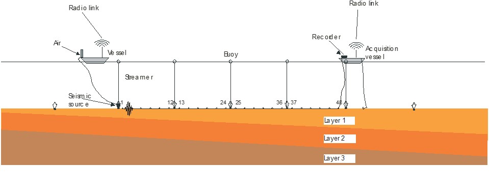
In transition zones or close to the coast, directional drilling are used to install pipelines. The transitional zones have very variable water heights with sea conditions which do not allow the use of conventional geophysics (sub-bottom profiler, seismic reflection) to obtain soil information.

The equipment is deployed on the seabed and seismic shots are carried out along the seismic device.

The seismic data are recorded on board and an online quality control is carried out in order to modify, if necessary, on the acquisition parameters.


  • Seismic refraction and UMASW using a static approach


Results

In the most of time for pipeline route survey, the shore approach can be a quite delicate phase to obtain suitable information of the geological layers. The sub bottom profilers or seismic reflection cannot not give enough data due to their limitation of the depth penetration which depends of the water depth. Today and for safety and environmental reasons, the HDD (Horizontal Directional Drilling) are used for the installation of pipeline in such areas which require geological information until 30 to 50 meters below the seabed.

Marine seismic refraction and surface wave performed in static approach provide P and S wave velocities information of the sediment over the first 20 to 50 meters below the seabed, in function of the equipment set-up deployed. The integration of both measurement leads to a better description of the geological layers.