Onshore Surface Wave – MASW


Generalities


The behaviour of materials under various types of loads is an important factor in the structural design which can be prone to the movements of grounds induced by earth tremors, passages of train, road traffic, an operation of machines, …

Moduli of rigidity of less than 0.001% are used in the design of these structures. As the modulus of rigidity is directly related to the shear wave velocity, it is possible to obtain this modulus after measuring the shear wave velocity. The modulus of rigidity measured by this way represents the modulus of rigidity for the very small deformations and thus provides the maximum measurement of rigidity (Gmax).

The surface wave is the both combination of compression and shear wave characteristics. They are guided waves propagating at the surface of the ground on a thickness close a wavelength (λ).

When these surface waves propagate in a medium made up of only one formation, their propagation velocity is constant. On the other hand, when this medium consists of several layers of different characteristics, then the propagation velocity of the wave is known as dispersive. This means that the propagation velocity is dependent the depth, i.e. of the frequency. That means that the wavelengths have different penetration depths


Multi Channel Analysis Surface Wave method (MASW)

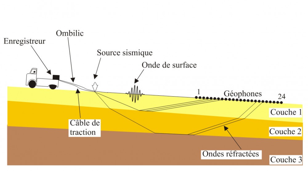
We generate a surface wave by using a land seismic source. The seismic waves (Rayleigh waves) are recorded by using a multi-channel streamer and a seismic recorder (one or more).

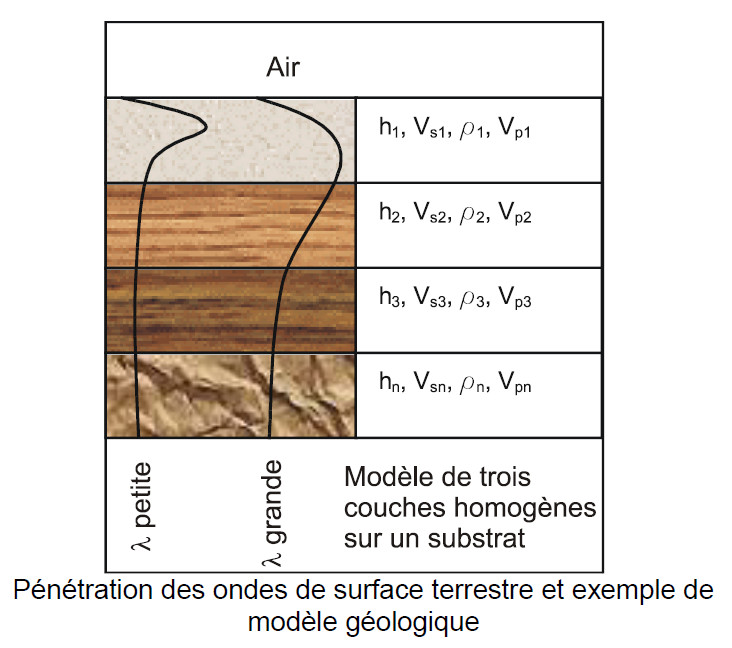
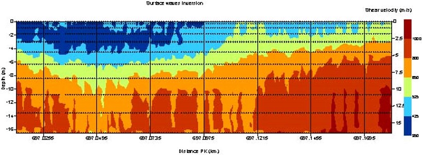
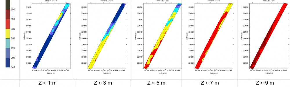
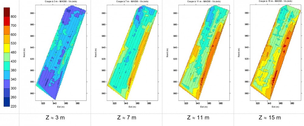
Our QC software of processing data on line calculates the curves of dispersion for each shot. These curves describe the properties of propagation of the surface wave. They are used to compute the shear wave velocity until 50 m of depth. As shear wave velocity is directly proportional to the modulus of rigidity, this gives us an immediate indication on the profile of the stiffness or rigidity of the grounds without having to carry out drilling, cross-hole or another expensive technique. This technique is non invasive.

  • Acquisition set-up for a land survey


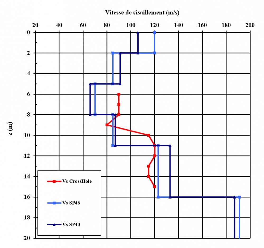
The traditional seismic methods used to measure compression and shear wave velocities are the cross-hole and down-hole which requires the use of drillings, expensive and long.

  • Correlation between the shear wave velocity
    obtained with the surface wave (Vs SP 46 and 40) and cross-hole


Key features

The surface wave velocity is very strongly bound to the shear characteristics of the medium (with more than 95%). The remainder is a function of the characteristics of compression of the medium and the density of materials. By analysing the dispersion of the surface wave, we obtain the profile of the shear wave velocity (Vs). As Vs speed is directly proportional to the modulus of rigidity of the ground (Gmax), this measurement informs us about the variations of rigidity of the medium. The geology of the ground is thus described in term shear wave velocity and rigidity.

It is also possible to measure shear wave velocity decreasing with the depth, which means that we can detect soft soil units under hard units.
  • The shallow depth geology of the ground is thus described in term shear wave velocity and rigidity (Gmax).
  • It makes it possible for a low cost to measure a profile of shear wave velocity (according to the depth), on linear several of kilometres. Thus the variations are more easily identifiable.
  • The penetrations observed are about 30m with maximum close relations of 50m. This penetration is a function of the characteristics of the soil and the techniques employed (seismic source, hammer, weight drop and recording of the noise micro-seismic (microtremor).
  • The shear wave velocity inversions can be measured when those are characteristic
  • The voids and cavities are detectable.
  • Interpretations have an error lower than 10%.


Applications

The surface waves have several applications including:

Studies of the site of constructions
  • Qualification of site for rough works,
  • Analyse risk of liquefaction, stability of slopes,
  • Cartography of the roof of the rock,
  • Cartography of the zones low shear wave velocity,
  • Calculation the shear wave velocity and estimation of the module of rigidity (Gmax) along profiles of several kilometres.


Study of the slopes and embankments:
  • Evaluation of the slopes, embankments,
  • Evaluation of the degree of compaction of the embankments,
  • Control of the concrete injection
  • Study of linear works
  • Evaluation of the roadways, roadway systems, tracks and tunnels


Equipment

Land equipment
  • Multi-channel streamers from 24 to 192 sensors
  • Seismic source (mass, falls of weight, shot gun, explosives, vibrating pot)
  • Seismic recorder (8 Geometrics GEODES)
  • Software of quality control on line
  • Software of processing data of wave of surface on line


  • 2D profile of the shear wave velocity using the surface wave analysis and a 72 geophones set-up


Key features

  • The land surface waves are usable everywhere where a surface is accessible,
  • Method for industrial environment using of the ambient noise (micro-seismic),
  • Average maximum penetration of about 30 m, and up to 50 m observed under certain conditions of site,
  • Detection of the inversions speed of the waves of shearing,
  • Measurement of Gmax modulus for very soft sediments and over consolidated formations or rock.


MASW Results

Shallow depth investigation – karstic area

  • Results obtained with 6 displays using 72 equally spaced (1m) geophones


Linear suvery, 2D cartography at constant depth

Area survey, 2D cartography at constant depth


MASW Analysis:
  • Is performed using classical seismic shots or microtremor (see SismOcean DCOS booklet).
  • Using microtremor processing is performed by seismic signal extraction (panels describe in the DCOS brochure) giving one shear wave velocity interpretation located for every geophones (one vertical profiles of shear wave every two meters for example). The high density of results enhance the local variations of the shear properties of the soil.

MASW analysis is well adapted for the qualification of industrial site: velocity inversion, under consolidated area, liquefaction risk …
In a noisy environment (urban or industrial) this approach permit to use the seismic ambient noise and to have shear properties information on the first thirty meters. The combination of both MASW and DCOS give a quick and complete site description using the same equipment and recorded data