Marine Seismic Refraction


Generalities


SismOcean is one of the few companies who propose marine refraction seismic in towed or posed mode and to have as much experience in this field.
Marine seismic refraction is a well-known technique that measures the velocities of in situ compression waves (P waves) using the refractive properties. It is a "direct" measurement method.

Marine seismic refraction produces profiles where the layers defined by the P-wave velocities are positioned as a function of the depth of the interface between the different layers. This depth is expressed in meters.

Operation

Marine Seismic Refraction relies upon proper records and analysis of refraction waves. The waves generated by the seismic source (air-gun), travel in the sediment and are refracted by the different layers (Snell and Descartes laws).

A multichannel streamer is dragged onto the water bottom and records the refraction waves. Using the same equipment and the same record it is possible to combine refraction and marine surface wave processing (see UMASW section).


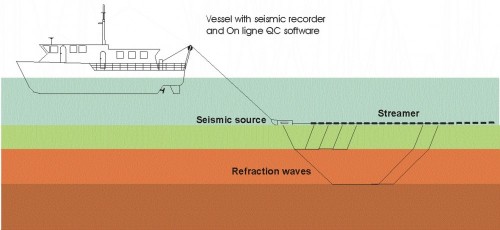
  • Acquisition set-up for Marine Seismic refraction


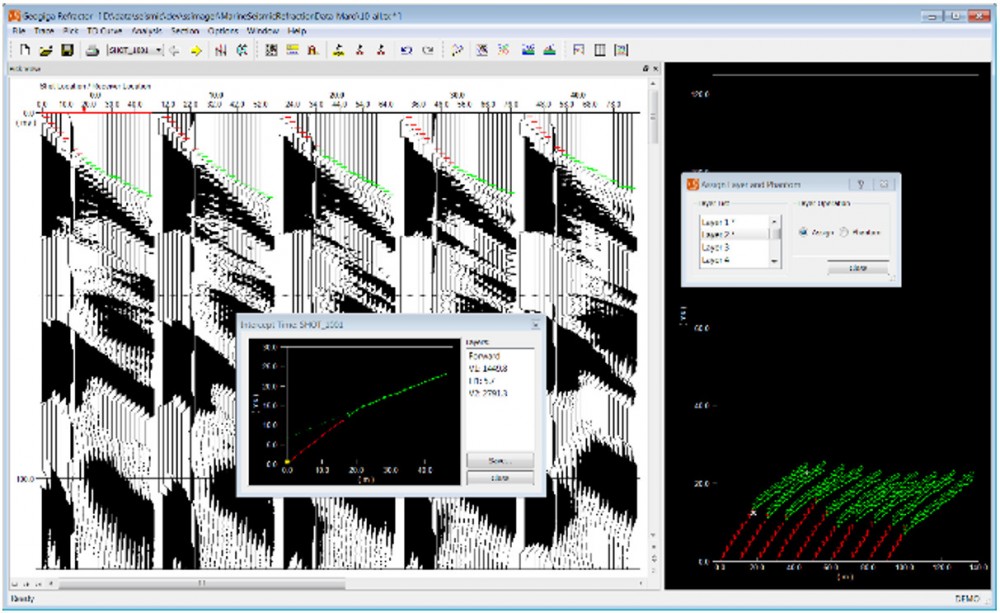
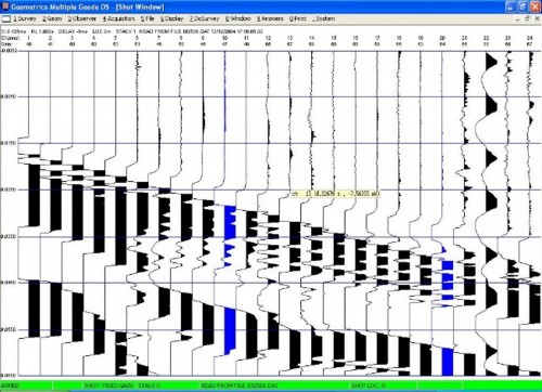
Our software for on-line data QC visualizes the receivers and the seismic signal recorded. The picking of the first arrivals give access to the P wave velocities of the soil and the position of the different layers. In function of the streamer length used, the nominal penetration can reach 20-25 meters.


  • On-line QC of the marine seismic refraction acquisition


  • First arrival picked and “dromo” visualization


Applications

Marine Seismic Refraction Survey has many applications including:
  • Pipeline/cable route surveys
  • Burial assessment
  • Pre-dredge geotechnical surveys
  • Reclamation quality control
  • Calibration of superficial geophysical data
  • Shallow foundation design, Suction anchors
  • Site investigations
  • Seabed templates
  • Bedrock mapping
  • Optimisation of sampling and geotechnical testing locations (CPT, coring, miniCPT, …)


Key features

  • Non-destructive tool.
  • The seismic layers are defined by their P-Waves velocities and thickness computed (in meters).
  • Soil conditions estimated over several hundreds of km.
  • The depth penetrations do not depend of the water depth.
  • Quick and reliable method

  • Operation in water depth between 0 and 50 m.
  • Depth investigation between 0 and 25 m.
  • Almost continuous profile of the P wave velocity along the survey line
  • Accuracy of the P wave velocity measured about 10%
  • Operation in very shallow water depth is possible.


Equipment description

Underwater equipment
  • From 24 channels up to 48 channels streamers
  • Receivers spacing adapted in function of the need.
  • Marine seismic source, Umbilical,...

On board equipment
  • Seismic recorder
  • On-line in-house QC software
  • On-line in-house surface wave data processing software


Results

To the results obtained by the seismic refraction it is possible to integrate the geotechnical data and to combine the seismic unit define by their P wave velocities to the boreholes’ geological information.


  • Marine seismic refraction and boreholes


In function of the soil condition, the same equipment and the same data acquired can be used for the refraction and surface wave interpretation (see example here below and UMASW section).


  • Analysis combination of both seismic refraction and surface wave results